Nearly a year ago, we announced the launch of the Climate Risk and Resilience Portal (ClimRR) along with our collaborators at the Federal Emergency Management Agency (FEMA) and the U.S. Department of Energy’s Argonne National Laboratory (Argonne). Since then, extreme weather events have continued to plague the United States. From hurricanes like Hilary and Idalia to tragic wildfires in Maui, there are no signs of these increasingly dangerous – and costly – events slowing down. With a year under our belt, we’d like to share our first case study, out of Idaho, that demonstrates the power of forward-looking climate data and its impact on the future resilience of our communities.
Looking back one year
As a company that’s invested billions of dollars in wireless and broadband network infrastructure, we’ve long recognized the importance of looking ahead to prepare for the unexpected. And given our changing climate, the historical approach to predicting future hazards was no longer sufficient to meet our planning needs. We’ve been collaborating with Argonne for several years to produce climate data that can help us better understand future risks to our network. And in 2022, we teamed up with FEMA and Argonne to launch ClimRR to help U.S. communities build resilience to climate-related threats, too.
ClimRR is a free, publicly accessible portal that provides localized, peer-reviewed climate data to policymakers, city planners and emergency managers, and state, local, tribal, and community leaders. It enables stakeholders to understand future climate threats to inform infrastructure design, hazard planning and much more.
Also in 2022 and recognizing a need to encourage state planning and strategies for future climate events, FEMA released an updated State Mitigation Planning Policy Guide. This guidance requires all states to plan for climate change and equitable outcomes when they create a Hazard Mitigation Plan (HMP). This means the Hazard Identification and Risk Assessment section of HMPs must now address future climate, population, and land use projections in order to be approved by FEMA.
With the new FEMA requirements in effect and ClimRR data at their disposal, the Idaho Office of Emergency Management (IOEM) began collaborating with AT&T to utilize the portal’s forward-looking climate data in the creation of the state’s latest HMP.
ClimRR Case Study: Informing Hazard Mitigation Planning in Idaho
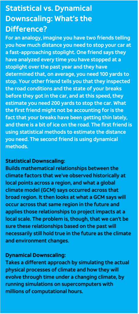
The data in ClimRR projects future climate conditions at the local level. While most modeling tools rely strictly on historical statistics to create future projections (statistical downscaling), what sets the ClimRR portal apart from other modeling tools is its use of dynamical downscaling, taking additional factors and developments in the earth’s climate system into account that others may overlook.
Together, AT&T and IOEM integrated an analysis of this forward-looking data into the state’s new Hazard Mitigation Plan. The state’s plan is now with FEMA for review and approval.
Not only will the findings from ClimRR enhance the state’s ability to prepare for the years and decades ahead – they also demonstrate the portal’s potential utility for other states and communities across the country.
Impact
From the onset of our engagement with IOEM, we immediately recognized their concern for safeguarding communities and essential industries for Idaho’s economy.
To ensure we were providing adequate data points to help IOEM plan for these concerns, we engaged in several conversations with IOEM. This communication helped us determine what information would be most beneficial to the office, as well as provided us with key contexts of historical extreme events. We were then able to develop a platform that meets IOEM’s specific needs, resulting in a case study that exemplifies the impact of transforming data into local knowledge.
As we develop plans and design our built environment for the future, science-based projections available in ClimRR can help us understand what our infrastructure will need to endure. Using ClimRR and with AT&T’s support, IOEM has been able to develop an updated HMP that meets FEMA requirements. This plan is currently with FEMA for review. Thanks to the insights from ClimRR, the HMP outlines actionable plans that once adopted will help mitigate the loss of life and property from future climate hazards.
“At IOEM, our priority is protecting communities and the industries that are vital to Idaho’s economy,” said Ben Roeber, Preparedness and Protection Branch Chief at Idaho Office of Emergency Management. “Working with AT&T to get specific data that meets our needs will allow us to have a more unified approach to plan development locally and across the state.”
Key Findings: ClimRR Projections for Idaho
ClimRR provides projections for two carbon emissions scenarios (RCP 4.5 and RCP 8.5). The analysis revealed the following projections for Idaho throughout this century:
Less frequent, but more intense precipitation. Under the RCP 4.5 scenario by the end of the century, Idaho is projected to experience increases in annual precipitation, particularly in the North, North Central, and Southwestern regions of the state, with increases of 10 or more inches. However, the maximum number of consecutive days with no precipitation is also projected to increase for almost every county, indicating a higher potential for drought between the less frequent but more intense precipitation events.
Expanding wildfire risk. Dangerous Fire Weather Index values are projected under the RCP 8.5 scenario to spread eastward throughout this century from Boise across the Snake River Plain, which could jeopardize crop yields and communities in these regions. The Fire Weather Index forecasts weather conditions that are more conducive to wildfires, but does not account for vegetation or ignition scenarios.
Increased summer daily temperatures. By the end of the century, under the more severe climate scenario, 20 of Idaho’s 44 counties are projected to experience average summer daily high temperatures of 90 degrees or more, with Payette and Canyon Counties reaching averages of 101 degrees.
What did we learn?
From our conversations with key stakeholders in Idaho, such as IOEM, we gained the following insights:
- Stay local: Breaking down the data by region was critical for the state to understand how each of the projections would impact their local communities differently based on local geographic and economic factors.
- Stay concise: Sharing data must be done carefully and succinctly to highlight important findings.
- Stay connected: Our work and insights were made increasingly valuable through review, feedback and input from local stakeholders.
- Stay relevant: Climate projections should accompany contextualized human impacts to denote urgency for both hazards and solutions. ClimRR is uniquely situated to provide this data.
The bottom line
FEMA’s new requirements for HMPs mean all states can greatly benefit from the forward-looking data featured in ClimRR. ClimRR provides robust climate projections including data for temperature, heating and cooling days, heat index, fire weather data, precipitation and drought. Projections for flooding will be available by the end of the year.
Many states may not know they have access to the insights that ClimRR offers and in turn might rely on high-level, qualitative summaries of how our changing climate will impact hazards. This could prove sufficient when considering hazards that are intuitive, like extreme heat, but for more geographically specific hazards, more granular data is necessary in order to plan for an evolving climate future.
Regardless of whether a stakeholder needs future climate projections to develop a Hazard Mitigation Plan that meets new requirements or design an infrastructure project that needs to last for fifty years or more, the engagement work that AT&T is doing with ClimRR can help equip stakeholders with meaningful and actionable climate projections.
Idaho is just one example of how together, we can build resilient communities that are prepared for whatever challenges the changing climate may bring.

